Finding Puna & Ulu Kai
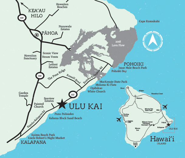
A part of what makes Ulu Kai so beautiful and relaxing is its remoteness. We are located on Kalapana-Kapoho Rd/ Coastal Highway 137, locally known as the Red Road, a narrow highway that travels 10 miles along the coastline of the lower Puna District.
Flying to Hawaii Island, the Big Island
There are two airports on the island with Hilo Airport being the closest to Ulu Kai. Kona Airport is on the other side of the island.
Option 1: Fly to Hilo International Airport (ITO)
Fly to Hilo International Airport directly, or from other island airports such as Honolulu on Oahu, Kahului on Maui, Lihue on Kauai, or Kona, which is west of us.
Option 2: Fly to Kona (KOA)
From Kona, Ulu Kai is a 2 1/2 - 3 hour scenic drive that takes you halfway around the Island of Hawaii, either the northern or southern routes, or across the island, taking the Saddle Road AKA the Daniel Inouye highway, passing Mauna Kea.
Once you are on the Big Island: Ulu Kai does not offer transportation or shuttle service. Your best option is to rent a car. Be sure to check with airlines about their offerings of special car rental rates!. A regular taxi or Uber costs about $125 one way from Hilo to Ulu Kai.
There is very limited public transportation via the Hele-On county bus that leaves from the downtown Hilo Bus Station (a few miles from the airport). This is a slow, but inexpensive option, that stops at the Kalapana Seaview subdivision a half mile away. For more info visit the Hele-On bus website.
Driving to Ulu Kai from the Hilo International Airport (ITO) : 45 minutes
Driving to Ulu Kai from the Kona International Airport (KOA): 2.5 - 3 hours
A part of what makes Ulu Kai so beautiful and relaxing is its remoteness. We are located on Kalapana-Kapoho Rd/ Coastal Highway 137, locally known as the Red Road, a narrow highway that travels 10 miles along the coastline of the lower Puna District.
Flying to Hawaii Island, the Big Island
There are two airports on the island with Hilo Airport being the closest to Ulu Kai. Kona Airport is on the other side of the island.
Option 1: Fly to Hilo International Airport (ITO)
Fly to Hilo International Airport directly, or from other island airports such as Honolulu on Oahu, Kahului on Maui, Lihue on Kauai, or Kona, which is west of us.
Option 2: Fly to Kona (KOA)
From Kona, Ulu Kai is a 2 1/2 - 3 hour scenic drive that takes you halfway around the Island of Hawaii, either the northern or southern routes, or across the island, taking the Saddle Road AKA the Daniel Inouye highway, passing Mauna Kea.
Once you are on the Big Island: Ulu Kai does not offer transportation or shuttle service. Your best option is to rent a car. Be sure to check with airlines about their offerings of special car rental rates!. A regular taxi or Uber costs about $125 one way from Hilo to Ulu Kai.
There is very limited public transportation via the Hele-On county bus that leaves from the downtown Hilo Bus Station (a few miles from the airport). This is a slow, but inexpensive option, that stops at the Kalapana Seaview subdivision a half mile away. For more info visit the Hele-On bus website.
Driving to Ulu Kai from the Hilo International Airport (ITO) : 45 minutes
- Leaving the Hilo airport, turn left at traffic light onto Kanoelehua Ave/ Highway 11 South.
Continue on Hwy 11 until you are out of town (about 5.9 miles). - Turn left onto Kea’au Pahoa Bypass Road/ Highway 130 South.
Continue for 21 miles (passing Pahoa). - Shortly after sighting the ocean and passing a green church on the left, just past mile-marker 20, you'll see a large sign which says, "End of Road-1 mile." Get in the left-hand turn lane.
- A sign will direct you either to Kalapana or End of Road. Turn left towards Kalapana, then curve right.
- Follow this short road to a stop sign at a T-junction and turn left onto Kalapana-Kapoho Rd/ Coastal Highway 137.
- After about 5 miles, between the 17 and 18 mile-markers, a half-mile beyond Kalapana Sea View Estates, Ulu Kai will be on your left at the sign for Kalani Honua Hale Aloha.
Driving to Ulu Kai from the Kona International Airport (KOA): 2.5 - 3 hours
- Make a left out of the airport and drive north on Route 19.
- Continue on Route 19 through Waimea, down the Hamakua coast (still Route 19) until you get to Hilo.
- Past the waterfront side of town, make a right onto Highway 11 at Ken’s House of Pancakes (sign says Volcano 30 miles).
- Continue on Hwy 11 until you are out of town (about 5.9 miles).
- Turn left onto Kea’au Pahoa Bypass Road/ Highway 130 South and continue for 21 miles (passing Pahoa).
- Shortly after sighting the ocean and passing a green church on the left, just past mile-marker 20, you'll see a large sign which says, "End of Road-1 mile." Get in the left-hand turn lane.
- A sign will direct you either to Kalapana or End of Road. Turn left towards Kalapana, then curve right.
- Follow this short road to a stop sign at a T-junction and turn left onto Kalapana-Kapoho Rd/ Coastal Highway 137.
- After about 5 miles, between the 17 and 18 mile-markers, a half-mile beyond Kalapana Sea View Estates, Ulu Kai will be on your left at the sign for Kalani Honua Hale Aloha.